Long Bien Bridge Guide: History, Walk & Local Life
Walk Hanoi's working Red River bridge — 1902 French-era steel, wartime scars, Bai Giua gardens and practical safety tips — with Old Quarter and Dong Xuan pairings.
By Dinh16 min readLong Bien & Hoan Kiem District, Hanoi
Introduction — answer first
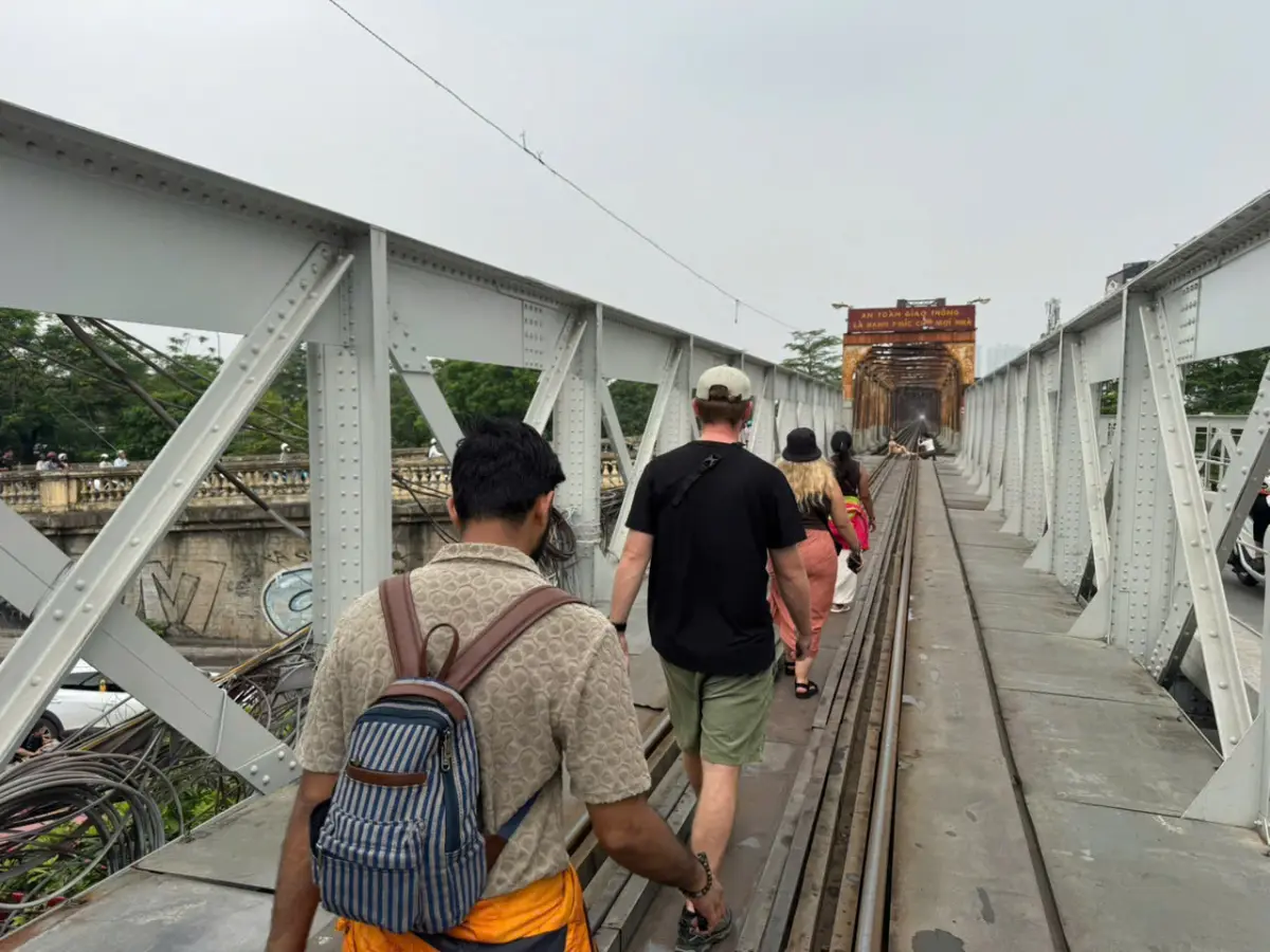
Can you walk Long Bien Bridge? Yes. Thousands of Hanoians cross it daily on foot and motorbike. As a visitor, treat it as an active transport corridor, not a pedestrian park: stay alert for trains, keep to the edges when traffic passes, and do not assume rail schedules posted online are current — confirm locally and listen for horns. See also our complete guide to visiting Hanoi.
Is it worth visiting? If you have three or more nights in Hanoi and already walked Hoan Kiem Lake and the Old Quarter, Long Bien delivers something the lake cannot: scale, river, and twentieth-century history in one frame. Paul, who leads heritage walks, puts it this way: guests who skip the bridge remember shops; guests who walk it at dawn remember how Hanoi connects to the Red River.
The Eiffel question: Social media often claims Gustave Eiffel designed Long Bien. The bridge shares visual DNA with other late-nineteenth-century French metal structures, but attribution to Eiffel is not documented the way it is for, say, the Eiffel Tower or certain Saigon buildings. Treat "Eiffel bridge" as folklore unless you are citing primary colonial records. The honest story — colonial engineering, repeated wartime damage, post-war reconstruction — is compelling without the name-drop.
For first-timers with 48 hours, prioritize the lake and Old Quarter. For four nights, add Long Bien on a clear morning after Dong Xuan Market.
History — why this bridge matters
Long Bien opened as Pont Doumer in 1903, named for the French Governor-General of Indochina. It was among the longest bridges in Southeast Asia at the time — a statement of colonial ambition linking Hanoi (then part of the protectorate administration) across the Red River to rail lines and hinterland trade.
The structure you walk today is not a single untouched 1902 artefact. American bombing during the Vietnam War targeted the bridge repeatedly because it was a critical supply route — the famous photograph of a gaping hole in the span circulates in every history gallery. Vietnamese engineers repaired it under fire; sections were replaced; some spans show patchwork metal beside older riveted beams. That layered scarring is the point: the bridge is living infrastructure with memory, not a restored prop.
After reunification, Long Bien remained essential. Trains still run to northern provinces; motorbike traffic uses deck lanes; fruit wholesalers cross from Dong Xuan side routes. Understanding that continuity helps you visit respectfully — workers are commuting, not performing for your camera.
Background reading: French influences in Hanoi · History of Thang Long and modern Hanoi.
Geography — where the bridge sits in your mental map
The bridge connects:
- South / city side: Near the Old Quarter's northern edge and Dong Xuan Market wholesale streets
- North / Long Bien side: Residential and industrial fringes, river paths, access toward Bai Giua (the mid-river alluvial island known locally as "the island between two rivers")
From Hoan Kiem Lake, the walk north through O Quan Chuong direction takes 15–25 minutes depending on heat and photo stops. Many guests combine: dawn market at Dong Xuan → coffee → bridge walk → return via O Quan Chuong Gate and the Old Quarter.
Grab drivers understand "cầu Long Biên" — specify which side you want dropped at if you are walking one direction only.
Walking the bridge — practical route
Before you start
- Footwear: Closed toes with grip — deck plates can be uneven; dew makes metal slick at dawn
- Weather: Clear sky for photos; avoid storms (open exposure, lightning risk)
- Bag security: Like any busy corridor — phone in front pocket on crowded sections
- Trains: If a train approaches, do not stand on rails; move to marked edges. Schedules shift — check station boards or ask vendors nearby rather than trusting blog timetables
Suggested walk (90 minutes)
- Start city side near Dong Xuan / Hang Dau area after early coffee (06:00–07:00 ideal in cool months)
- Walk slowly north — pause mid-span for Red River panorama: banana plots on Bai Giua, high-rises west, low-rise east
- Reach Long Bien side — optional descent to riverbank paths if local access is open (conditions change; follow signage and do not enter fenced construction)
- Return same route or loop via Grab to Old Quarter for late breakfast
Paul's group rule: never run on the deck for Instagram — motorbikes expect predictable pedestrians.
Photography notes
- Golden hour warms rust and river mist; blue hour after sunset suits skyline contrast
- Midday blows out sky and heats metal — worst window
- Tripods: Possible mid-span off-peak; stay clear of traffic lanes
- Drone: Assume restricted near transport infrastructure — verify current Civil Aviation rules; do not launch from deck without permission
Bai Giua — the island between rivers
Bai Giua Song Hong (often shortened to Bai Giua) is the fertile strip visible from mid-bridge — vegetable plots, seasonal farming, occasional grazing. It is not a formal tourist park. Some visitors hire boats from informal landings on the Long Bien bank for closer views; safety and pricing vary — negotiate before boarding, wear life jackets if provided, and skip overloaded craft.
Shaw, who photographs Hanoi for our story library, recommends viewing from the bridge first before committing to a boat: the island reads best as context in a wider river composition. If you go ashore, treat farms as private livelihood — ask before walking through plots.
Pair island views with best time to visit Hanoi: October–November haze softens light; summer storms build dramatic clouds but interrupt walks.
Comparison — Long Bien vs other Hanoi "icons"
| Long Bien Bridge | Hoan Kiem Lake | Train Street | |
|---|---|---|---|
| Cost | Free | Free | Free (access unstable) |
| Best for | River scale, war history | Orientation, daily life | Novelty rail proximity |
| Safety | Active traffic — alert | Very high | Variable; enforcement changes |
| Time needed | 1–1.5 h | 1–3 h loops | 30–60 min if accessible |
| First-timer priority | After night 3 | Day 1 | Optional / caution |
| Tour value | High with guide narrative | Self-walk fine | Low reliability |
Train Street appears in many reels; our complete guide treats it cautiously because cafe access and safety rules change without notice. Long Bien is legally public and historically substantive — a better use of the same "industrial Hanoi" curiosity.
Pairing with Dong Xuan and the Old Quarter
The efficient half-day north Old Quarter loop:
| Time | Stop |
|---|---|
| 06:00–07:30 | Dong Xuan Market wholesale floors and periphery food |
| 07:30–08:00 | Coffee on Hang Dau or Chuong Duong street |
| 08:00–09:30 | Long Bien walk (cooler, softer light) |
| 09:30–11:00 | Return via O Quan Chuong Gate → deeper Old Quarter guild streets |
This sequence beats bridge-first at 10:00 — you miss market rhythm and walk metal in heat.
Evening alternative: sunset walk outbound only, Grab back after dark if legs are tired. Weekend Old Quarter noise stays south; the bridge feels oddly quiet except for traffic hum.
Food after: pho or bun thang vendors near Dong Xuan periphery — see street food culture for ordering confidence.
What to wear and carry
No dress code like a temple, but modest and practical wins:
- Hat, sunscreen, water (limited shade on span)
- Light layer in Dec–Feb dawn (river wind)
- Camera strap secured — gusts occur
- Cash for market coffee and boat if used — many vendors cash-first (5,000–25,000 VND snacks)
Seasonal and daily timing
| Season | Bridge experience |
|---|---|
| Oct–Nov | Clear air, comfortable dawn walks — top window |
| Mar–Apr | Warm mornings; occasional drizzle — grip matters |
| Dec–Feb | Cool, sometimes misty — moody photos; dress warm |
| May–Sep | Start before 07:00 or after 17:00 only |
| Tet | Less wholesale traffic at Dong Xuan; bridge still active — confirm market hours locally |
Read month-by-month: best time to visit Hanoi.
Safety — honest assessment
Long Bien is not dangerous by default — it is unforgiving of inattention:
- Trains have right of way; horns may be your only warning
- Motorbike streams do not stop for photo poses in lane
- Gaps and grates exist — watch footing, especially with children
- Pickpocket risk is moderate in crowded market approaches, not mid-span at dawn
- Solo female travellers at sunrise report no systemic issues — standard urban awareness applies
If mobility is limited, skip mid-span — views from city-side abutment still deliver river context without full kilometre exposure.
Getting there — step by step from Hoan Kiem
Most first-timers approach from the lake and Old Quarter, not from the Long Bien district side.
Walking route (25 minutes with stops): From Hoan Kiem north shore, follow Dinh Tien Hoang north until the street narrows toward Hang Dau. Continue toward Dong Xuan — you will feel wholesale energy increase (motorbike loads, foam boxes, shouted weights). Pass the market building's east flank; the bridge abutment appears as metal structure and traffic hum above rooftops. This walk teaches how goods reach the Old Quarter before you step on the span.
Grab / taxi: Pin "cầu Long Biên" or show driver the bridge photo. Drop either city side (near Dong Xuan) or Long Bien side if walking back toward market. Expect 40,000–70,000 VND from French Quarter hotels in normal traffic.
Cyclo: Possible from lake — negotiate 100,000–150,000 VND one-way; fun but slower than walking at rush hour.
Motorbike taxi (xe om): Fine for one-way; insist on helmet.
Not recommended: Hop-on-hop-off bus stops rarely align with dawn market timing — walk or Grab.
Return navigation: If disoriented on Long Bien side, Grab to Hoan Kiem rather than guessing alleys. If walking back, aim for O Quan Chuong Gate — the last surviving Old Quarter gate — as your south anchor.
Wartime story — what guides point out mid-span
You do not need a military history degree to read the bridge — you need to look at metal.
Mid-span, Paul asks guests to find three textures: original riveted French-era beams, welded replacement plates from American-war repairs, and newer guard rails from post-1990s safety upgrades. The famous bomb-damage photographs often show a single gap; the real structure tells a sequence of hits and rebuilds. Vietnamese engineers kept the crossing open under conditions that explain national pride in infrastructure resilience.
Interpretation note: Do not treat bomb damage as photo props for thrill-seeking poses. Commuters cross beside you; many families lost relatives in the same conflict that scarred the steel.
If you want deeper twentieth-century context before walking, read history of Thang Long and modern Hanoi the night before — thirty minutes reading makes mid-span silence land harder.
Families, solo travellers, and mobility
Families with children: The bridge is not a playground. Older children who follow instructions can walk dawn crossings; strollers are impractical on deck plates and crowded ramps. Better plan: one parent walks mid-span at sunrise while the other stays at Dong Xuan periphery breakfast — swap roles next morning if both want the view.
Solo female travellers: Dawn and sunset walks are routine for locals; standard urban awareness (bag forward, ignore over-helpful strangers offering "private boat" without price) suffices. Our editorial team has no pattern of bridge-specific incidents — heat and traffic remain bigger risks than crime mid-span.
Mobility-limited visitors: Partial experience from city-side abutment still delivers river panorama without full kilometre. Skip if balance issues make grates and uneven plates dangerous.
Photographers with heavy gear: Tripods workable off-peak; guard against lens condensation at river dawn in winter months.
Red River context — why the crossing beats a lake loop again
Hoan Kiem is myth and daily exercise; the Red River is trade, flood, and geography. Hanoi exists where the river meets lowland agriculture — Long Bien is the human answer to that scale. From mid-bridge, notice silt colour, sandbank shifts, and east-west development asymmetry: high-rises cluster west; east stays lower and greener toward Bai Giua.
Flood season (roughly July–October) can raise water dramatically — dramatic photos but access paths change. Confirm locally before descending to informal boat landings; respect police tape during typhoon recovery.
Link: Complete guide to visiting Hanoi for flood-season travel adjustments.
Evening and night — different bridge, same rules
Some guests prefer sunset outbound from city side, Grab back after dark. Night adds skyline lights west and headlight streaks — compelling for photographers with tripod discipline. Safety rules tighten: visibility drops, motorbike density stays high, drunk tourist behaviour stands out — walk sober, wear visible clothing, no rail-line photos.
The bridge is not lit for tourism — ambient city glow only. Expect a working corridor, not a light show.
Pair post-sunset with Ta Hien Beer Street only if you walked morning market already — beer replaces sleep, not wholesale education.
Local expert insights
Paul (heritage walks): "Guests expect a monument. I start by showing them a timetable photo at the rail office — when they realise trains still cross, they walk differently. Stand aside, let the freight pass, then look at the patched girders. That is the lesson."
Dinh (trip planning): "Schedule Long Bien the same morning as Dong Xuan or you waste a Grab twice. Never sandwich it between Ba Dinh and lake — geography fights you."
Shaw (photography): "One good frame beats fifty mid-span selfies. I wait for a farmer's boat below Bai Giua, bridge leading lines, Old Quarter haze behind — shoot from the north side looking south if pollution layer cooperates."
Market vendor rhythm: Wholesalers peak 05:00–08:00; bridge foot traffic rises after 07:00 when office workers commute — two different moods on one walk.
Guide vs solo: Solo is fine for orientation; a heritage Old Quarter tour that includes bridge context explains which bomb damage is original span versus replacement — hard to self-read.
Closing — what to read next
Long Bien rewards visitors who already understand Hanoi's lake-and-lane core and want river scale. Execute with:
- Dong Xuan Market — same-morning wholesale context
- Hanoi Old Quarter guide — guild streets after the bridge
- French influences in Hanoi — colonial engineering backdrop
- Complete guide to visiting Hanoi — fit bridge into night count
- Best time to visit Hanoi — season your dawn alarm
Walk help: Heritage Old Quarter tour · City highlights walking tour · Free tour of Hanoi
You visited well if you can explain why the bridge was bombed and why it still runs trains — and if you stepped aside for a freight car before taking the photo.
FAQ — quick answers
Is Long Bien Bridge free to visit? Yes. There is no ticket booth for walking the deck. You may pay for coffee, market snacks, or optional boat hire separately — typically 5,000–50,000 VND for small purchases; boat prices vary by season and negotiation.
Did Gustave Eiffel build Long Bien Bridge? Not confirmed. The bridge was built by French colonial engineers in 1902–1903. Eiffel's company worked on other Indochina structures, but Long Bien is widely mislabelled online. Stick to documented history when guides or captions matter.
When is the best time to walk Long Bien Bridge? Sunrise (05:30–07:30) for light and cooler air; sunset (17:00–19:00) for golden tones. Avoid 10:00–15:00 in hot months. Train frequency changes — listen for horns and confirm at station boards rather than relying on blog schedules.
How long does it take to walk across? Plan 45–90 minutes return at photo pace, longer if you explore Long Bien bank paths or Bai Giua viewpoints. One-way plus Grab back saves time.
Is Long Bien Bridge safe for tourists? Generally yes with active awareness — trains, motorbikes, uneven plates, and sun exposure are the main risks. Not ideal for young children unsupervised or mobility-limited visitors needing smooth surfaces.
Can I combine Long Bien with Dong Xuan Market? Yes — recommended. Do market first at dawn (06:00–08:00), then walk the bridge while light stays soft. Same geography, one coherent north Old Quarter morning.
Where do I start the walk? Most visitors start the city / Old Quarter side near Dong Xuan and Hang Dau, walking north toward Long Bien district. Grab to "cầu Long Biên" if you prefer one-way.
Is Bai Giua island open to tourists? There is no single official gate; access is via informal paths and boats with variable safety. View from the bridge first; if boating, negotiate price, use life jackets, and respect farmland as private work space.
Local tips
- →Arrive at Long Bien Bridge Guide at opening or late afternoon — Hanoi midday tour groups peak hard.
- →Pair Long Bien Bridge Guide with one nearby stop in the same district, not a city-wide scavenger hunt.
- →Group Long Bien Bridge Guide with nearby sights in the same Hanoi district to cut cross-town Grab time.
- →Walk to Long Bien Bridge Guide early; Hanoi heat and scooter density rise after 09:30.
Good to know
- Long Bien Bridge Guide ticket rules and camera policies can change — verify at the gate, not only in blogs.
- Shade and seating near Long Bien Bridge Guide are limited; carry water in warm Hanoi months.
- Near Long Bien Bridge Guide, Hanoi street vendors often need small cash even when hotels take cards.
- Tet and festival weeks change opening patterns for Long Bien Bridge Guide — verify that week’s hours.
Before you go
- Before you go: check whether Long Bien Bridge Guide closes for ceremonies or maintenance that week.
- Wear shoes you can remove quickly if Long Bien Bridge Guide requires it.
- Screenshot offline maps for the blocks around Long Bien Bridge Guide before you enter dense Hanoi lanes.
Common mistakes
- ✕Believing Eiffel designed it — Repeat the documented colonial story; skip the myth in captions.
- ✕Midday walk in July — Metal radiates heat; miserable and flat photos.
- ✕Standing in the rail line for video — Trains use the bridge; enforcement is not gentle.
- ✕Visiting without Dong Xuan — You miss the supply-chain story that explains river crossing.
- ✕Expecting a visitor centre and toilets — There are none on span; go before you walk.
- ✕Full crossing then walking back in noon traffic — One-way walk + Grab return is smarter summer strategy.
- ✕Drone launch without checking rules — Fines and confiscation happen.
- ✕Two-night itinerary forcing Long Bien — Lake and Old Quarter first; bridge is night-three-plus.
- ✕Comparing to Golden Gate aesthetics — Long Bien is utilitarian beauty; wrong expectation breeds disappointment.
- ✕Ignoring O Quan Chuong Gate on return — the last Old Quarter gate completes the historical loop.
Practical information
- How to get there
- Walk 15–20 minutes north from Hoan Kiem Lake to the western bridgehead near Hang Dau / Tran Nhat Duat, or Grab to either end.
- Best time to visit
- 05:30–07:30 or 16:30–18:30. Avoid midday heat on exposed steel.
- Suggested itinerary
- Dong Xuan morning → Long Bien walk → Old Quarter lunch → rest → evening lake loop.
- Nearby attractions
- Dong Xuan Market
- Hanoi Old Quarter
- O Quan Chuong Gate
- Hoan Kiem Lake
Frequently asked questions
- When was Long Bien Bridge built?
- It was built between 1899 and 1902 under the French colonial administration and originally named Paul Doumer Bridge.
- Can pedestrians cross Long Bien Bridge?
- Yes. Narrow lanes on either side of the central railway track are open to pedestrians, cyclists and motorbikes at all hours.
- How long does it take to walk across?
- About 25–30 minutes one way at a relaxed pace, or roughly an hour for the round trip with photo stops.
- Did Gustave Eiffel design Long Bien Bridge?
- No. The bridge is often associated with Eiffel because of its late-19th-century French steel construction, but it was designed and built by other French engineering firms of the period.
From the road
Related real moment
A photo journal from Hanoi — not a traveller review, and not proof that every detail in this guide happened on that walk.

Related content
Knowledge hub
Hanoi Landmarks →Historic landmarks, temples, markets and iconic places that define Hanoi.
Destination hub
Hanoi →Related stories
- Dong Xuan Market Guide: Hanoi's Historic Trading HubNavigate Dong Xuan Market like a local — wholesale floors, honest bargaining, nearby food, weekend night market and how to pair it with Long Bien and Old Quarter walks.
- O Quan Chuong Gate: Hanoi's Last Old Quarter GateSee O Quan Chuong — the last remaining gate of Hanoi's Old Quarter — with history context, traffic-aware photo tips and a northern loop linking Dong Xuan, Bach Ma and Long Bien.
- Hanoi Train Street Guide: Life Along the TracksVisit Hanoi Train Street the right way — current access reality, café seating rules, safety, photo etiquette and how to pair it with an Old Quarter walking day.
- Hanoi Old Quarter Guide: Streets, Food & Walking LogicNavigate Hanoi's Old Quarter with local walking logic — guild streets, markets, food timing, night energy and how to pair the lake without turning the district into a checklist sprint.
- French Colonial Heritage in Hanoi: Architecture, Food and Everyday LifeHow French Indochina shaped Hanoi's boulevards, baguettes and coffee culture — and where to see that legacy today without confusing history with a walking route.
- Complete Guide to Visiting Hanoi (2026)The ultimate 2026 cornerstone guide to Hanoi — how many days, top sights, neighbourhoods, food, transport, itineraries, safety, budget and day trips from local experts.